Boston North Shore Study
Regional Saugus River Floodgate Project - Everett, Lynn, Malden, Nahant, Revere and Saugus, Massachusetts

The Study and Project
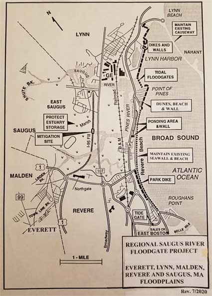
 The Regional Saugus River Floodgate Project is the primary option to regional protection which is being re-evaluated and updated in the Boston North Shore Study. The project is a coastal flood protection project to provide a very high level of protection to the Cities of Revere, Lynn, Malden and Everett, and the towns of Saugus and Nahant, Massachusetts. The region, five (5) miles north of Boston, is the most vulnerable area along the Massachusetts coast to storm surge flooding and sea level rise.
The US Army Corps of Engineers New England Division investigated solutions to the problem with 5 Steering Committees over 4 years ($2.6 million). The Recommended Regional Project includes a Floodgate structure at the mouth of the Saugus River with nine (9) gated openings 500 feet wide, designed to provide safe passage for navigation and the natural tide levels and flushing in the 1,650-acre tidal Estuary landward of the gates. The Estuary would be purchased and managed to protect its flood water storage and environmental resources. The gates would be tied to 3.1 miles of shorefront improvements along Lynn Harbor, Point of Pines and the Revere Beach Reservation. The 1.5-mile Nahant Causeway would be protected and maintained since it significantly reduces wave action in Lynn Harbor, mouth of the Saugus River and at Point of Pines. The project would protect 5,000 buildings, 8,000 housing units, 10,000 residents, 20,000 employees and 400,000 commuters in the region against the worst coastal storm likely to occur, the Standard Project Northeaster (SPN), and against sea level rise, estimated damages at $ 1.3 billion.
With 1.5 feet of sea level rise from 1980 to 2050, the SPN floodplain would increase from 5,000 buildings to about 6,000 buildings that would be protected by the project. The increase is attributed to both an estimated growth in development of about 4%, and an increase in the SPN floodplain by 2050 since the 1980 period of about 1.5 feet.
Building Locations SPN Floodplain SPN Floodplain & Estimated 4%
In 1990 Report 1-ft Sea Level Rise Growth TOTAL
City of Revere 2,670 340 110 3,120
Town of Saugus 900 150 40 1,090
City of Lynn 1,200 150 50 1,400
City of Malden 210 40 10 260
City of Everett 100 20 -- 120
TOTAL 5,990
Building sand dunes and beaches at Point of Pines and along Revere Beach and the Nahant Causeway using the I-95 sand could also reduce overtopping. The use of this sand could remove 4,900 feet of the embankment restoring 16.7 acres of ecosystem habitat and restore flushing to the upper estuary. Breaching and removing the I-95 embankment to restore the wetlands is a major goal of resource agencies.
The Secretary of Environmental Affairs after the NEPA/MEPA review provided a positive Certificate, the Commonwealth then supported it, and the US Congress authorized the Project for construction. Then in the fall of 1993 a new Secretary of Environmental Affairs, an environmental activist from Rhode Island, was opposed to construction along the Massachusetts coast and the project was stopped, and since it has been de-authorized. Renewed interest in the Project by the communities due to coastal flooding and accelerated sea level rise has resulted in the Boston North Shore Feasibility Study which was authorized by the President on 23 Dec 2022 to investigate the flooding and ecosystem needs of the region.
IMPACT OF SEA LEVEL RISE
The impacts of accelerated sea level rise on the region and project were evaluated by the Corps original Project Manager using the forecasted rates of sea level rise adopted by the Corps of Engineers of 5-feet and by the Massachusetts Office of Coastal Zone Management of 7.8-feet by the year 2100. The potential damages to the estimated 6,000 to 7,000+ buildings would be in the billions of dollars impacting 100,000 residents and employees and half a million commuters. The preliminary cost of the Regional Floodgate Project for SPN protection would be about $300 million initially as sea levels rise 5- to 8-feet. Without the Floodgate Project the Region would need to be protected with walls and dikes up to 12 feet high along roads and yards for the 25-miles of estuary shorefronts at a much higher cost than the Floodgate Project. A non-structural plan to raise all buildings up to 12-feet high would cost considerably more than the Floodgate Project while roads and yards would be continually or frequently under water. The cost to totally evacuate the floodplain with the removal of all buildings would be in the order of $15 billion or more.