Boston North Shore Study
Regional Saugus River Floodgate Project - Everett, Lynn, Malden, Nahant, Revere and Saugus, Massachusetts

Selected Regional Floodgate Project
Regional Saugus River Floodgate Project
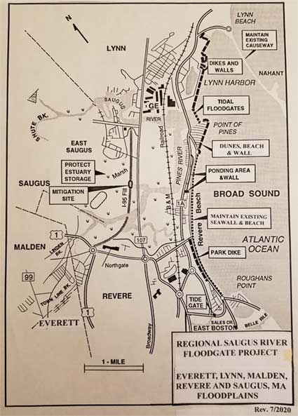
Project protects nearly entire region against the SPN & sea level rise with structural & non-structural measures. The region includes the Cities of Everettt, Lynn, Malden and Revere and the Town of Saugus, Massachusetts floodplains. The floodplain includes 5,000 buildings, 8,000 housing units, 10,000 residents, 20,000 employees and 400,000 commuters who pass through the floodplain enroute to Boston on 5 major arteries or rails. The Project includes Floodgates across the mouth of the Saugus River tied into 3.1 miles of shorefront improvements along Lynn Harbor, Point of Pines and Revere Beach, and purchase of the 1,650 acre Estuary. With 2.5 feet of sea level rise, buildings protected increases from 5,000 to about 6,000.
Most residents would be removed from the high risk floodplain & FEMA maps revised, eliminating flood insurance premiums.
Following state support Congress authorized it for construction in WRDA 92. The Project was strongly supported by communities, legislators, and state sponsor. The project progressed through 4 years of Planning at $2.5 million, followed by 2.5 years of final design at $ 6 million--- a lot of work was accomplished to plan and design this Project.
Lynn Shorefront Features
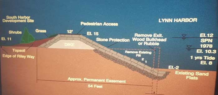
- 4,300 ft. of dikes
- 4,445 ft. of walls
- Collect road storm drains with outfall placed behind floodgate structure.
- Maintain Nahant Causeway
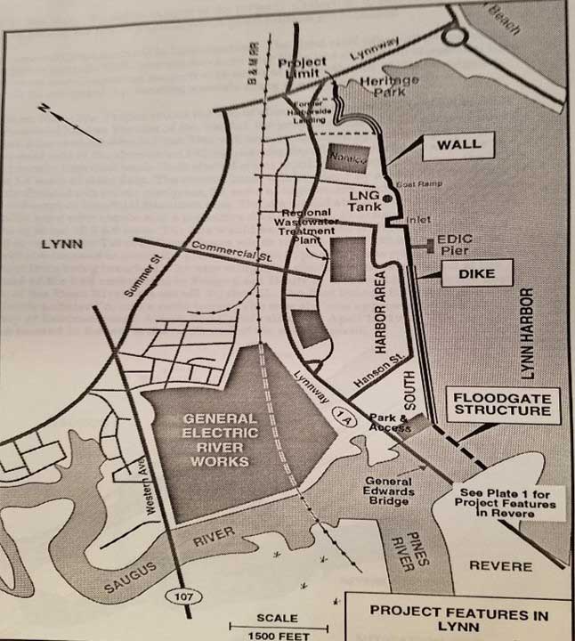
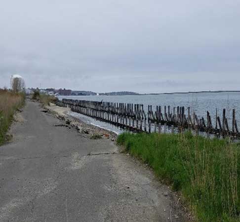
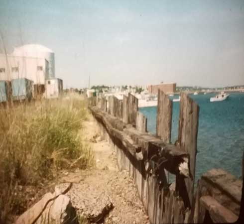
See March 1, 2020 photos of Lynn Harbor shorefront with description of proposed improvements.
Lynn Harbor Existing Bulkhead
Lynn Harbor Proposed Shorefront Dike
Revere Project Features
Tidal Floodgates
At Point of Pines: 3,150 ft. Dunes, 900 ft Wall along Saugus River
At Revere Beach: 20 ac. Ponding area & 500 ft. Wall
3,420 ft. Parkland Dike
Maintain Existing Revere Beach’s Seawall & Beach
Sales Creek Tide Gate
Estuary: Acquire & Manage Estuary Storage Area & Resources
Point of Pines
Most vulnerable shorefront with over 3,000 acre-feet of SPN overtopping in the first 870 feet of wall. This volume of water is equal to the neighborhood covered 50 feet deep. Of course, water would flow out by the Yacht Club and across the Lynnway to the Pines & Saugus Rivers. The rivers would be overtopping their banks contributing to ponding in the neighborhood up to 6 feet deep. 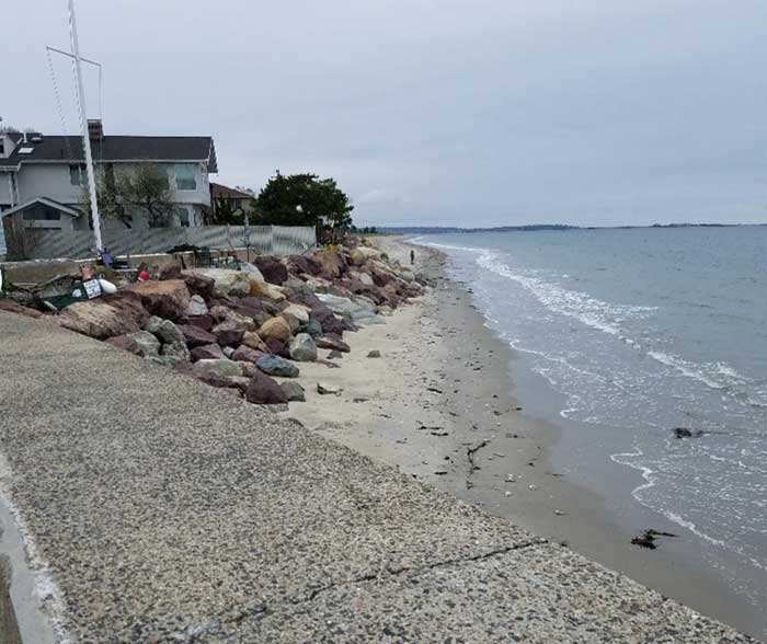
Point of Pines' Proposed Sand Dune Restoration - 3,150 Feet--The Corps' Coastal Engineering Research Center conducted numerical and physical modeling and recommended a dune/beach system all along the shorefront to achieve SPN protection, in lieu of a lower level of protection with revetments. The dunes would be constructed of heavier grained sand which is "extremely resistant to erosion and overtopping even against the SPN". Built to a similar elevation as existing dunes, maintenance must be assured. The most vulnerable 1,550 feet of exposed shore could be built up with I-95 sand early during construction with 100,000 cubic yards. While the remaining northerly 1,600 feet of dunes could be replaced with the 110,000 CY re-used from breaching the I-95 Embankment (assuming approved) after the Floodgates are built. Surveys of Revere Beach before and after the 1991 Halloween Storm showed that the I-95 sand was very resistant to erosion.
 See March 1, 2020 photos of Point of Pines shorefront with description of proposed improvements.
Revere Beach Park Dike - 3,420 Feet Long, Located Both Sides of MDC Police Station

Proposed Revere Beach Parkland Dike would stop the tides which overtop the seawall from reaching developed areas.
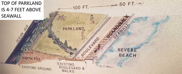 See March 1, 2020 photos of Revere Beach with description of proposed improvements.
Estuary Storage Protection Program
The 1,650 acre salt water Estuary located in Lynn, Revere and Saugus would be acquired in fee and include a full time Environmental Manager, plus
Regulatory / Enforcement:
- Local /State assurances for strict enforcement
- High priority project for federal enforcement
Monitoring:
- Frequent tours & inspection
- Points of contact
- Illegal activities reported in media
Education:
- Maps provided of wetland storage boundary
- Coordinate with conservation commissions, et al
- Provide brochures & news releases of wetland / storage need
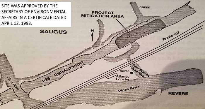
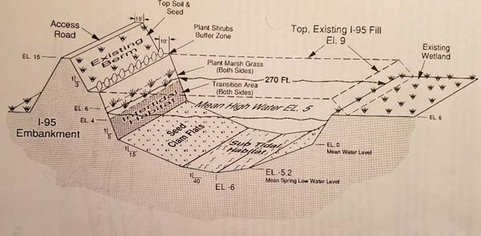
Proposed Mitigation Site In Saugus To Create 4.8 Acres Of Intertidal Habitat--If the I-95 embankment is breached to restore 500 acres in the upper Estuary Wetlands, a separate Mitigation site would not be required. The breached areas could be planted with marsh grass and seeded with clams.
See March 1, 2020 " Photos" of Rumney Marsh estuary, issues and video.
Mitigation Section At I-95 Embankment
Selected Location For Tidal Floodgates
Floodgates prevent flooding and eliminate the need to raise 25 miles of shorefront up to 12-14 feet high & provides a Harbor of Refuge for 400 vessels.
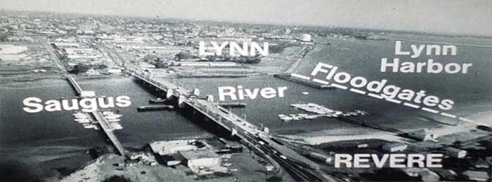
See March 1, 2020 " Photos" of Floodgate location and artist renderings.
Major Floodgate Design Criteria
Design for SPN storm tide and sea level rise, safe passage for navigation and provide for no impact on tide levels and flushing in the 1,650 acre salt water Estuary.
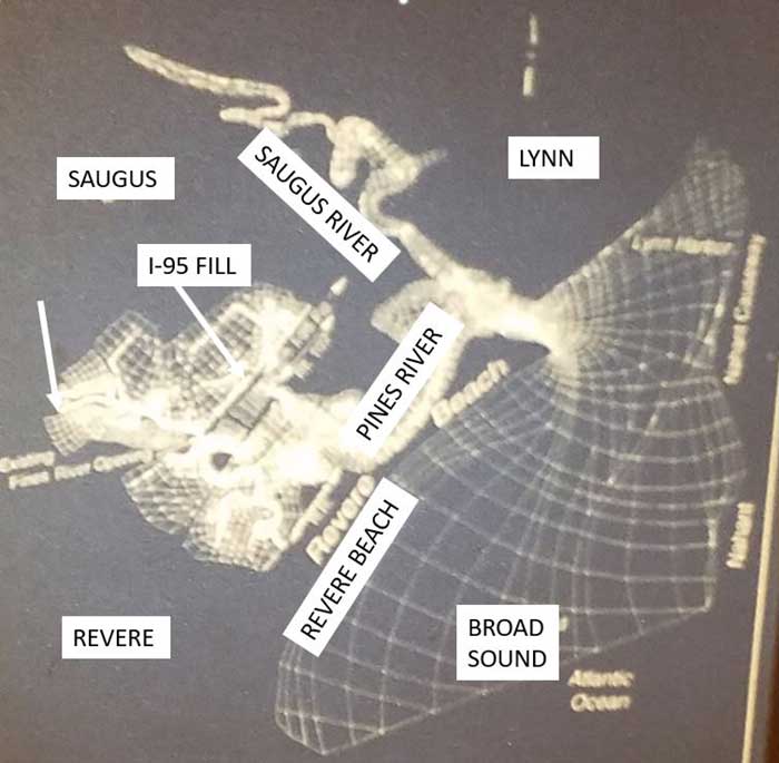
Saugus/Pines River Estuary Numerical Model
Tide Gages were installed throughout the estuary and Broad Sound, and measured to calibrate both physical and numerical models.
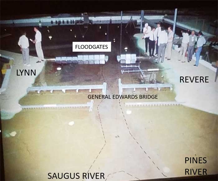
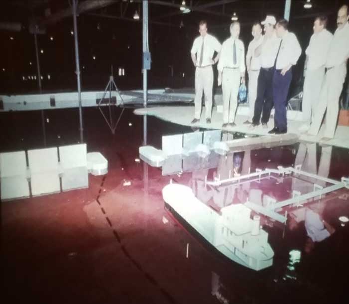
Floodgate Physical Model
Being viewed by members of Citizen Steering Committees and Technical Group. MODEL: 1:50 Scale; 110 feet long, 80 ft. wide; Reproduced area: 600 ft. south of Point of Pines; Lynn Harbor 2,000 ft. NE of General Edwards Bridge; and 1,200 ft. upstream of GE Bridge.
Model built by Corps of Engineers’ Waterways Experiment Station in Vicksburg, MS.
Physical Model
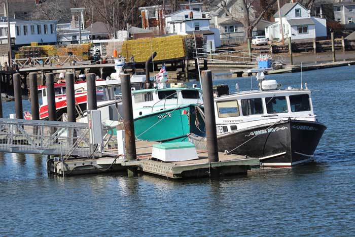
Scale models of the Floodgates, the General Electric oil tanker, and Saugus’ lobster boats were built and used to evaluate safe passage for navigation, maintain natural flows/tide levels in the Estuary, location and size of gates, and sea level rise. Harbor masters were among the CSCs to visit and operate the vessels.
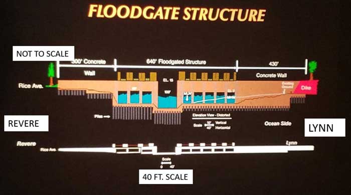
Floodgate Structure
The structure spans 1,370 ft., includes
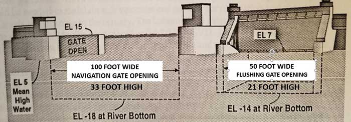
One 100 foot wide, 33 foot high navigation miter gate, and eight (8) 50 foot wide, 21 foot high flushing tainter gates.
Navigation and Flushing Gates
The structure & gates would be designed so they can be modified for higher rates of sea level rise, and be closed in 20 minutes.
Floodgate Operation
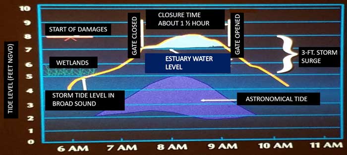
Gates would be operated when storm threatens to cause damages. (Below is a sample operation.)
